
Land Verification ReportComplete Due Diligence
01Property details
- Location
- Kira Municipality, Wakiso District
- Title reference
- Block 000, Plot 000 (sample)
- Tenure
- Mailo
- Size claimed by seller
- 0.50 acres (50 decimals)
- Asking price
- UGX 60,000,000
- Site visit
- 9 October 2026
Overall verdictFLAGGED
Ownership and title check out, but a possible boundary claim and a size shortfall were found. Do not pay a deposit until the boundary claim (4.5) and size shortfall (4.4) are resolved.
02Summary of findings
| Check | Finding | Status |
|---|---|---|
| Registered owner | Matches the seller's ID | Verified |
| Title authenticity | Confirmed at the land registry | Verified |
| Mortgages, caveats, charges | None registered | None found |
| Court records | No pending cases found | None found |
| Boundary markers | 3 of 4 found on site | Partial |
| Measured size | ≈ 0.47 acres vs 0.50 claimed | Shortfall |
| Neighbour and LC1 enquiries | Neighbour claims part of east boundary | Flagged |
| Occupation on the land | Unoccupied; no crops or structures | Verified |
03Title and registry search
A search at the land registry confirmed the title is genuine and registered to the seller. The name and ID on the title match the documents the seller provided. No mortgages, caveats or other charges are registered against the plot, and no court cases involving the plot or the seller were found in the records searched.
04Site inspection
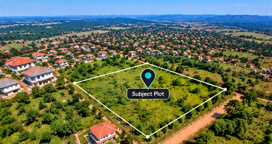


- 4.1 Location. The plot is where the seller described, about 300 m from the main road, reached by a 6 m murram access road.
- 4.2 Boundaries. Three of the four boundary markers were found. The north-east marker is missing and could not be located.
- 4.3 Condition. The land is unoccupied and gently sloping, with no visible signs of flooding or recent construction.
- 4.4 Size. A GPS walk of the boundary measured about 0.47 acres, roughly 6% less than the 0.50 acres claimed.
- 4.5 Local enquiries. The LC1 chairperson confirmed the seller is known locally. One neighbour says the east boundary should sit about 3 m further west.
05Risk assessment
- HighPossible boundary dispute (east side). If unresolved, part of the plot could be contested after purchase.
- MediumSize shortfall. The measured area is smaller than claimed, which affects the fair price.
- LowTitle and encumbrances. No issues found in the records searched.
06What we could not verify
The seller had not yet supplied the deed plan, so the measured size is based on our GPS walk and is approximate. The missing north-east marker means that corner could not be confirmed on the ground.
07Recommended next steps
- Ask the seller for the deed plan and have a registered surveyor re-open the boundaries, with the neighbour present.
- Resolve the east boundary claim in writing, witnessed by the LC1, before any payment.
- Renegotiate the price to reflect the confirmed size.
- Have your lawyer review the sale agreement before signing.